Hall Of Fame -Our History

Sanchare' was talented enough to receive The Presidential award for a consecutive period of 3 years. Without Ur helping hands i don't think v must have not succeeded the dream. Thanks you very much for making sanchare the No 1 programme.
- Nade Gura & D Nade -
_____________________________________________________________________
Showing posts with label Monaragala district. Show all posts

LAHUGALA KITULANA NATIONAL PARK


This park is one of Sri Lanka's smallest but most valuable con-servation areas for elephants and endemic birds.
Location :
Park lies in the basin of the Heda Oya, 16km inland from the coastal town of Pottuvil in Eastern Province. The Pottuvil Moneragala trunk road runs through the south eastern sector of the park.
Access :
The route would be the same as the approach to Yala East Na-tional Park from Colombo. The routes fork off at Pelmadulla and meet again at Wellawaya, one going via Beragala, Koslanda and the other via Thimbolketiya, Udawalawe and Thanamalwila. From Wellawaya the route would be via Moneragala. It is approxi-mately 318km from Colombo. The park office is situated at Lahugala.
Physical Features :
 The terrain is flat with occasional rock outcrops. The park fea¬tures three tanks, Lahugala (243ha), Kitulana and Sengamuwa, which ultimately drain into the Heda Oya. These tanks are largely silted up and support an abundance of beru grass. The area of the park is l,554ha.
 Climate :
Mean annual rainfall is 1650 mm. There are two dry periods, from May to October and from mid-January to March. The north¬east monsoon lasts from November to the end of December. Date and
History of Establishment : 
The area was declared as a sanctuary on 01st July 1966 upgraded to national park on 31st October 1980. Cultural Heritage :
Nearby is the historic site of Magulmahavihara, built for the occasion of King Kavantissas's marriage to Viharamaha Devi.

View lahugal in a larger map

Galoya(gal oya) - Boat-ride.


The only National Wildlife Sanctuary of Sri Lanka which offers an opportunity to travel through it by boat, is the Galoya Wildlife Sanctuary. The journey may span a minimum of 07 to 08 hours. Between 05 and 10 people could travel in one boat while the amount per person is Rs. 650.00. A fee of Rs. 400.00 is charged generally for the whole group, as service charges. As the distance travelled reduces, the fee decreases. The final destination of the Galoya Boat-ride is the area known as Makara, situated 17 kilometers away.

The extent of the Iginiyagala reservoir is 9324 hectares. The Galoya Wildlife reserve surrounding it is 25,900 hectares in extent. On the South is the Badurawela mountain range, and on the North, the Danigala and Degela wela ranges. Apart from Galoya, the Sellakkaoya and Kaballa bay oya join the reservoir
From the season starting from October, birds are seen almost everywhere. They are seen to build nests on a decayed tree standing in the middle of the Iginiyagala lake and the surrounding islands during this period. One of the places in Sri Lanka where swimming elephants could be observed is Galoya. Apart from tortoises, the types of fish such as Thilapiya, Korali, Rogu and Catalo are present in the reservoir.
Permission is given to rest and cook food at the destination of the trip, "Makara". Apart from this, for such needs, a few "Galgewal" are situated in the surroundings. They are, the galge-poosa, galge-drakapula and the galge-annasi. The best time for the trip is the period from March to October. It is advisable for bird-watchers to carry a telescope and camera.
-Chakrith Koththagoda-

View Gal oya       

GPS Tracking By Sala GIS
 

Butthala


Ruhunu, Maya and Pihiti comprised the ancient Tri-Sinhale. The Ruhunu Rata or Rohana Deshaya was an independent kingdom spread over about three-fourth of the country. The Uva province which belonged traditionally to Rohana, was declared in 186 to be a separate administrative unit.

When studying the religious, cultural and social history of Sri Lanka, the Uva province receives a special place. At times, the history of Uva extend beyond the Anuradhapura era, and pre-Vijayan history.

According to the Mahavamsa, by the first century A.D, Uva had been known as Huawa (Mahawamsa, Chapter 60). There is evidence to suggest that the present name, Uva had been coined in the 17 th century.

The boundaries of Uva.

The Maha Disava of Uva is as large as 3277 1/8 square miles. About 32 square miles are reserved for water reservoirs. While one boundary is the Mahaveli river, on the other side, the Walwe river, Galoya, Kubukkanoya, Manika river, Kiridi oya, Walawe river and the mountains they originate from, bring great beauty to the Uva province.

The boundaries of Uva according to a folk-song are,
From the southern and Eastern sides,
Marked by the Sripada
And the Walawe river
The bounderis of Uva were marked
Kistorical Yudaganawa.

The Historical Yudaganawa cheithya situated in the Monaragala District, is of great historical value.
The Yudaganawa temple is located about 2km from the Buttala town, on the Monaragala-Wellawaya road. Surrounding the temple are the Manik river on the East, the Puhulgala Mountai range on the North, the Yudagana river and a paddy field on the west, and Buthgal or the Buttala city on the South.

The largest templeever built in Sri Lanka is the Yudagana temple and is 1038 Square feet in circumference.
There are many legends regarding the Yudagana temple. One of them is that King Dutugemunu built the temple to ward off the sins of war with his brother Saddhathissa. The opinion of Prof. Senerath Paranawithana is that the temple is the ancient Cheeragama or Keeragama which was built for the demise of king Parakuba’s (1153-1186).

History bears evidence that the Yudaganawa temple was built in the 2 nd Century A.D. by King Mahanaga. It is believed that the king had built a thousand temples in the area. According to the Mahawamsa, the Dutugemunu-Saddhathissa war took place here.

The Maligawila Buddha Statue.

The Maligawila temple had been known in the past as Ariyakara. The villagers believe that the name was changed to Maligawila on account of the great palace and lakes in the area. The Maligawila temple is spread on 250 acres of land.
The history of Maligawila runs back to the 7 th century and 8 th century A.D. Historically, the statue here had been built by King Dappula.

There are many theories about the height of the Maligawila statue. It is 54 feet and 110 tons in size. There is evidence that the statue had been made in another place, and transported here. This is the only temple that has been built without any supports, and is an important Thereada Buddhist statue

Dambgoda Buddha Statue.

When travelling about a kilometer on the road near the Maligawila statue, the Dabegoda Bodhisatva statue is seen. This area was known as Kana grama in the past, referring to the healing of eye diseases.
The dabegoda Statue is an Apa Loketheesvara statue. This statue, with Mahayana influence, shows evidence of a seven storied building built around it. The two eyes of the statue depict the sun and moon. According to folklore, gems were placed in the eyes in the past.

This area was known as Dewala kanda in the past, and had been dilapidated for some time, and reconstructed in the 1990’s.

Dematamal Viharaya

From butthala

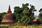
The Dematamal Vihara which is situated in the Okkampitiya Grama Sewa Wasama of the Buddata Divisional Secretatriat of the Monaragala district, is a Buddhist place of worship with great historical importance. The Dematamal Viara is recorded as the first Panchawasa Vihara in the country, ( containing Cheiththiya, Pilima Geya, Seemawa shala etc…)
According to the story, rhe Dematamal Vihara had provided protection to prince Saddhatissa. It is a famous fact that the two brothers were against each other. The prince Tissa who lost the war had hid at the temple. The priests had tried to secretly transport the prince out of the temple. Prince Gemunu having seen this had said, “Tissa, Don’t do that!” Therefore, it is thought that Dutumal became Dematamal.

It is reasonable to say that the Dematamal Vihara is a special Vihara in the country, since a Upa Pala decorated the kotha, similar to the Shanthi Stupa system of India. This is the only cheiththiya to have a Upa Pala. The Upa Gala is 18 feet in height. A rare guardstone can also be seen.


Also, after turning at the Kubukkana junction and travelling about 6 km, turning to the right from Okampitiya, this temple can be reached.


Yatiallathota.

This Vihara is situated far from the Buttala city at Palawaththa.

The history of this Vihara begins with king Mahanaga. When the queen had felt the need to deliver her child at Mannaram diya, she had said that the child should be caught. Thus, the place became Yatiallathota.
Later on, a palace, Bisokotuwa and Cheiththiya were built in the area. Another folk-tale is that the water had been brought there from the Yudaganawa tank. According to inscriptions, King Nissankamalla had renovated the vihara. The historical Kutumbala Vihara is situated nearby.

Chakrith Koththagoda-

Buttala hotels
Galapita Eco Lodge
Hena Eco Loge-0772990299

View Butthala in a larger map

Lunugamvehera National Park

The Lunugamvehera National Park
The Lunugamvehera National Park was designed to protect water-ways and to provide a resting-station for elephants, migrating between the Eastern section of the Yala Wildlife Conservation and the Western side of the Udawalawa National Park. As the biodiversity
in this area, including elephants is considerable, in order to conserve the area, it was declared a National Park under the Wildlife and Conservation Act and on December 8th 1995.

Borders of the park.

This National Park which belongs to the Divisional Secretariats of Thanamalwila, Wallawaya, Kataragama and Buttala of the Monaragala District of the Uva Province covers 23,498.08 hectares of land.

Ways to reach the park

While the main office of the park is situated on the Hambanthota-Wallawaya road, there are two roads leading to the park.

01. Travelling 245 km, passing through Udawalawa Thanamalwila from Cololbo.
02. Travelling through Colombo, Galle, Matara and Hambanthota, passing the Weerawila Junction and travelling 280km on the Wallawaya road.
03. Apart from this, travelling from Kataragama,passing the Gamudawa Junction and traveling acros Tammanawa, 18 km, takes a traeller to Lunugamvehera.

The park could be accessed through two main roads. Those are, the road situated at the edge of the bank of the Lunugamvehera wewa and through the black bridge situated near the Conservation Office at Thanamalwila.

Geographical Features.
In this park which is situated in the wet-zone, small hillocks can be seen here and there. The height from the sea-level is usually 91 meters. The beautiful mountain at a height of 20 meters is the highest point of the park.

Plant-life.

The eoc-systemc onsists of Dry zone and evergreen forests. Weera, Kone, Palu, Hik, Kunumallawa, Kirikone, Ulkenda, Kappetiy and Coffee plants are commonly seen.

Wildlife

Due to the grass the gas that grows around the Lunugamvehera lake, many wild animals could be seen arriving here searching for food. Among them are many elephants and buffalo apart from dandulena, Porcupines, Kola diviya, MOngoose, Wild boar, Mimiththa and Spotted deer.

Among the types of bird which live here are the native Jungle fowl which faces a threat of extinction. Among the reptiles could be seen the Crocodile, Star tortoise, and Pala Polanga.

Archelogical ruins of Pas Kema (Waterholes), Hathkema and seven vihara, a cave-painting and stone inscription can be seen.

The main lakes of the park.
The Weheragala lake has been built by obstructing the Menikgaga at Weheragala. It was opened in 2008, and was built by Mr. Gunadasa, a Sri Lankan engineer, using traditional Sri Lankan building techniques. Also, the Lunugamvehera lake has been built by obstructing the Kirindi Oya at Lunugamvehera.

Guest houses.

Two Guest HOues to serve loval and forieign tourists visitng the Park have been built. They are,
1. Thalgaha digana
2. Weragala

Each Guest house is built near the river, and are equiped with all facilties, including food, while 20 guests could lodge at one time. Reservations could be made t the main Wildlife Office at Colobo

රන්මිහිතැනRanmihithanna:Mahinda Rajapaksha Tele Cinema village


Ranmihithanna: A road with some locations in the 1st tele cinema village in the Sri Lanka. There are more locations built permanently for designed tele dramas and cinema in Ranminithanna Mahinda Rajapaksha Tele Cinema village. Directors & producers able capture many shots to their cameras in local and foreign locations, many cultural locations and many climate locations.

රන්මිහිතැන: ශී‍්‍ර ලංකාවේ මුල්ම ටෙලි සිනමා ගම්මානයේ, දර්ශන තල කිිපයක් සහිත මාවතකි. සිනමා සහ ටෙලි නිර්මාණ සදහා අවශය විවිධාකාරයේ ඉසව් (^Locations) රන්මිහිතැන්න, මහින්ද රාජපක්‍ෂ ටෙලි සිනමා ගම්මානය තුළ ස්ථිරව ගොඩනගා ඇත. මෙරට සහ පිටරට විවිධ ප‍්‍රදේශයන්, විවිධ සංස්කෘතීන්, විවිධ දේශගුණතත්වයන් සහ විවිධ නිර්මාණ ක‍්‍රමයන් කැමරා වල සටහන් කර ගැනීමට නිර්මාණකරුවන්ට හැකියාව ලැබේ.


View Ranmihithanna in a larger map

Gal Oya National Park -Gal-oya special*

Bookmark and Share
After the successful entry of “Nilgala”, the sanchare team visited “Gal-oya National park” for this week programme. Gal Oya National Park in Sri Lanka was established in 1954 with an area of 25,900 hectare surrounded by Senanayake Samudra. The park serves as the main catchment area for Senanayake Samudraya. Senanayake Samudraya was built under the Gal Oya development project by damming the Gal Oya at Inginiyagala in 1950

From Galloya

Nilgala


Bookmark and Share


Nilgala park which is in the Uva provinces of Sri Lanka is now open for the general public. The forest spreads over 26000 hectares and administered by both forest and wildlife conservation departments of Sri Lankan government. The park can be approached either from Colombo-Kandy-Bibila, on Bibila-Inginiyagala road or on Bibila- Batticoloa road.

The Historical way to Buttala - Katharagama ( Kataragama )-පරණ පාරක් දැන යමු කතරගම


Bookmark and Share


Whatever is your religion, you might have gone to Katharagama at least once in your life. But the route which took you there might be either the road through Hambanthota or the road through Ambilipitiya. But there is another path which leads to Kathragama though it is not much popular during recent times. That is the Buttala – Sellakatharagama road which begins from Badalkumbura.

Long ago this route has been the most famous route to Katharagama. But later this route has been abandoned, which became quite unpopular. But when the Gammudawa construction work was done this road was developed to a certain extent. Yet it is not very famous. May be that is why the evidence of the travelers in the past, still remains there. At that time the consumers of this road might have travelled either by foot or cart, which were the popular means of travelling at that time.

Once you get Badalkumbura you can reach this track which has a length of 20 km. This road has fallen mostly parallel to the Manick stream though it moves away at certain places.

There are a number of places where our ancestors have rested on their way to Katharagama. Madama is one such a place where a wayside rest (Ambalama) has been situated. Waanemangkada, Thimbulketiya, Galge, Bhaay Lindha, Galkema are few other such places which are worth mentioning. Walliamman Aru, a place that we meet on our way is another place which should be mentioned. According to folk tales Walli Matha had swung on a swing at that place. Though this route has a history as well as a story unknown as that, it has been abandoned unfortunately.
This might be a great experience if you intend to follow the footprints of our ancestors.
If you intend to have this experience, Hena Holiday Resort is the best option. They will arrange this trip for you along with comfortable accommodation. Contact 0772990299.
-Dilan Dharshana-
කතරගම වන්දනාවේ යන උදවියගේ ජනපි‍්‍රයම කැලෑ පාර වන්නේ පොතුවිල්, ඔකඳ පානම හරහා යාල උද්‍යානය ඔස්සේ වැටී ඇති මාවත වේ. එහෙත් බඩල් කුඹුරෙන් ඇරඹී බුත්තල, පැලවත්ත හරහා සුන්දර මැණික් ගග ඉවුර දිගේ කුඹුක් ගස්, මාර ගස්, වැලි තලාවන් පසුකර සෙල්ලකතරගම දක්වා කිලෝ මීටර් 20ක් පමණ වන අප සංචාරය ඔස්සේ ඔබට නැවත මතුකර දෙන්නෙමු. දැනටත් තැනින් තැන හමුවන මේ පාරේ ශේෂයන් අතර කිඹුල්කැටිය මඩම, වානේ මංකඩ, හැඳි කෙම, ගල් ගේ, බායිගෙ ළිඳ, වැනි සංධිස්ථාන මේ පාරේ චමත්කාරය පිළිබඳව අපට සේයාවන් සපයයි. හැත්තෑවේ සමගි පෙරමුණ ආණ්ඩුව විසින් බුත්තලම - කතරගම නව පාර කැපීමත්, කතරගම ගම්මුදාවට මෙම පාර අලුත්වැඩියා කිරීමත් නිසා ඌවේ සහ ඒ අවට අපේ පැරැණ්නෝ කරත්තවල නැග නැතිනම් දෙපයේ පිහිටෙන් හරෝ හරා කියමින් ගිය මේ අතීත මාවත කාලයේ වැලි තලාවට යටවී ගියේය. නැවත එය මතුකර ගැනීමට අපට හැකීවීම අප ලද භාග්‍යයකි. ඔබත් අප ගිය මේ පාරේ කතරගම යන්න. ඒ සඳහා හේන නිවාඩු නිකේතනය ඔබට මග පෙන්වාවි. 0772990299


View Buttala - katharagama in a larger map