Hall Of Fame -Our History

Sanchare' was talented enough to receive The Presidential award for a consecutive period of 3 years. Without Ur helping hands i don't think v must have not succeeded the dream. Thanks you very much for making sanchare the No 1 programme.
- Nade Gura & D Nade -
_____________________________________________________________________

Butthala


Ruhunu, Maya and Pihiti comprised the ancient Tri-Sinhale. The Ruhunu Rata or Rohana Deshaya was an independent kingdom spread over about three-fourth of the country. The Uva province which belonged traditionally to Rohana, was declared in 186 to be a separate administrative unit.

When studying the religious, cultural and social history of Sri Lanka, the Uva province receives a special place. At times, the history of Uva extend beyond the Anuradhapura era, and pre-Vijayan history.

According to the Mahavamsa, by the first century A.D, Uva had been known as Huawa (Mahawamsa, Chapter 60). There is evidence to suggest that the present name, Uva had been coined in the 17 th century.

The boundaries of Uva.

The Maha Disava of Uva is as large as 3277 1/8 square miles. About 32 square miles are reserved for water reservoirs. While one boundary is the Mahaveli river, on the other side, the Walwe river, Galoya, Kubukkanoya, Manika river, Kiridi oya, Walawe river and the mountains they originate from, bring great beauty to the Uva province.

The boundaries of Uva according to a folk-song are,
From the southern and Eastern sides,
Marked by the Sripada
And the Walawe river
The bounderis of Uva were marked
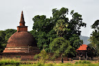
Kistorical Yudaganawa.

The Historical Yudaganawa cheithya situated in the Monaragala District, is of great historical value.
The Yudaganawa temple is located about 2km from the Buttala town, on the Monaragala-Wellawaya road. Surrounding the temple are the Manik river on the East, the Puhulgala Mountai range on the North, the Yudagana river and a paddy field on the west, and Buthgal or the Buttala city on the South.

The largest templeever built in Sri Lanka is the Yudagana temple and is 1038 Square feet in circumference.
There are many legends regarding the Yudagana temple. One of them is that King Dutugemunu built the temple to ward off the sins of war with his brother Saddhathissa. The opinion of Prof. Senerath Paranawithana is that the temple is the ancient Cheeragama or Keeragama which was built for the demise of king Parakuba’s (1153-1186).

History bears evidence that the Yudaganawa temple was built in the 2 nd Century A.D. by King Mahanaga. It is believed that the king had built a thousand temples in the area. According to the Mahawamsa, the Dutugemunu-Saddhathissa war took place here.

The Maligawila Buddha Statue.

The Maligawila temple had been known in the past as Ariyakara. The villagers believe that the name was changed to Maligawila on account of the great palace and lakes in the area. The Maligawila temple is spread on 250 acres of land.
The history of Maligawila runs back to the 7 th century and 8 th century A.D. Historically, the statue here had been built by King Dappula.

There are many theories about the height of the Maligawila statue. It is 54 feet and 110 tons in size. There is evidence that the statue had been made in another place, and transported here. This is the only temple that has been built without any supports, and is an important Thereada Buddhist statue

Dambgoda Buddha Statue.

When travelling about a kilometer on the road near the Maligawila statue, the Dabegoda Bodhisatva statue is seen. This area was known as Kana grama in the past, referring to the healing of eye diseases.
The dabegoda Statue is an Apa Loketheesvara statue. This statue, with Mahayana influence, shows evidence of a seven storied building built around it. The two eyes of the statue depict the sun and moon. According to folklore, gems were placed in the eyes in the past.

This area was known as Dewala kanda in the past, and had been dilapidated for some time, and reconstructed in the 1990’s.


Dematamal Viharaya

From butthala

The Dematamal Vihara which is situated in the Okkampitiya Grama Sewa Wasama of the Buddata Divisional Secretatriat of the Monaragala district, is a Buddhist place of worship with great historical importance. The Dematamal Viara is recorded as the first Panchawasa Vihara in the country, ( containing Cheiththiya, Pilima Geya, Seemawa shala etc…)
According to the story, rhe Dematamal Vihara had provided protection to prince Saddhatissa. It is a famous fact that the two brothers were against each other. The prince Tissa who lost the war had hid at the temple. The priests had tried to secretly transport the prince out of the temple. Prince Gemunu having seen this had said, “Tissa, Don’t do that!” Therefore, it is thought that Dutumal became Dematamal.

It is reasonable to say that the Dematamal Vihara is a special Vihara in the country, since a Upa Pala decorated the kotha, similar to the Shanthi Stupa system of India. This is the only cheiththiya to have a Upa Pala. The Upa Gala is 18 feet in height. A rare guardstone can also be seen.


Also, after turning at the Kubukkana junction and travelling about 6 km, turning to the right from Okampitiya, this temple can be reached.


Yatiallathota.

This Vihara is situated far from the Buttala city at Palawaththa.

The history of this Vihara begins with king Mahanaga. When the queen had felt the need to deliver her child at Mannaram diya, she had said that the child should be caught. Thus, the place became Yatiallathota.
Later on, a palace, Bisokotuwa and Cheiththiya were built in the area. Another folk-tale is that the water had been brought there from the Yudaganawa tank. According to inscriptions, King Nissankamalla had renovated the vihara. The historical Kutumbala Vihara is situated nearby.

Chakrith Koththagoda-

Buttala hotels
Galapita Eco Lodge
Hena Eco Loge-0772990299

View Butthala in a larger map

Mannar Island

Bookmark and Share

The Mannar Island which occupies an area of 1505.4 square kilometers, has been known historically by names such as, “Manthei”, “Mathota”, “Mahathiththa”, “Mahaputu” “Mawatuthota”. Mannar displays a similarity to the dry desert climate.

There are two main roads leading to Mannar. One is the road passing through Anuradhapura and Madwachchiya, along which 80km should be travelled to reach Mannar. The other is the recently opened road through Puttalam, Eluankulam, Silawatura and the Wilpattu National Park

.

From Mannar

The History of Mannar.

There exist many legends and beliefs regarding the History of Mannar. It is believed that King Vijaya and his retinue had landed in Sri Lanka at this site and that a bride from Madurai was transported between A.D. 505 and 543 across Mannar. (There is also a belief that they had com e here from the area known as Kudiramale, situated at the edge of the Wilpattu Wildlife reserve). Another folk-tale claims that King Ilanaga had escaped to Kerala due to enemy invasions, through Mannar. The Mahawamsa mentions that during the era of Kakusadha Budun, a Bo-tree had been planted at Mahathiththa.

From Mannar


Venkalai Bridge and the Bird-sanctuary

The Venkalai bridge connecting the Mannar Island is the longest island built in Sri Lanka. This bird-sanctuary is located on either side of the bride, between Paliyanthiv and Thirikenilwert, and is 4828 hectares in extent. This place which is a sanctuary of Migratory birds is a haven for about 200 types of birds. Siyakkaraya, Kabiliththa, Ranpath tharawa, Ul peda Tharawa, Petamathabatta are the main types. Apart from them, very rare species of animals have made this place their home, among them are, the Geta Kibula, and Muhudu oora. Mangrove plans and stretches of sand are found all over the Venkalai Sanctuary.

From Manna
Thiruketheeswaram Kovil.

Thiruketheeswaram Kovil is one of the famous Kovils built to worship God Eeswara. The others are the Muneshwaram kovil in Halawatha, Koneshwaram Kovil in Trincomale and Rameshwaram of India. This Kovil is situated near the A-32 road. There is a legend that the Kovil was built by Mayan, Ravana’s Uncle, while it is also believed that Rama had worshipped at this temple before travelling to India with Seetha. Another belief among the villagers is that a Brahmin of King Vijaya had worshipped at the temple. The temple is one of the legendary sites where Eeswara had performed many miracles.


Donkeys of Mannar.

Donkeys had been imported to Mannar from Somalia for daft purposes. These donkeys were transported to Puttalam and Kalpitiya too. They can still be seen in herds in the area.


Agriculture in Mannar.

The rainy season of Mannar is only two-months long. The day is much longer too. This climate is favorable for paddy-cultivation. Most of the cultivation is done using rain-water while 24,000 acres are nourished by the water of the Yada Wawa. The red-mixed Latirus soil is perfect for paddy cultivation, while the Data of the Agriculture department show that 170 bushels of paddy are obtained per acre.

Mannar Fort.

The Mannar Fort had been built by the Portuguese. After 1696, the Fort has been controlled by the Dutch. The English captured the fort on October 05 th, 1975. The Mannar port could be described as port that linked Sri Lanka to the world. Details about the Mannar port and fort are found in a stone inscription at Thamanhil island. Presently, the island is controlled by the Sri Lanka police.


Biobas tree.

The Biobas is a huge tree found on the Mannar island. The largest Biobas tree in Mannar is found about 2km from the entrance to Mannar island. The Biobas tree had been the favorite food of Camels brought to the island for draft.

Urumale beach

From Mannar

Urumale is a beautiful beach situated on the annar island. On a clear day, the light of the light-house situated in Rameshwaram, India could be seen at Urumale. The only place in Sri Lanka from which another country could be seen is the Urumale beach. The closest beach to India is the Urumale beach. The sand-hills of the Adam’s bridge which the legendary Hanumatha had used are seen at Urumale. A variety of fish are present in this sea-strip. Beautiful corals are also seen. Presently, this sea-strip is under the control of the Sri Lanka Navy.

-Chakrith Koththagoda-


View Manner Island in a larger map
Bookmark and Share

Kirala Kelle, Matara


Bookmark and Share
Kirala Kelle, as the Sinhalese name implies, is a ‘mangrove forest’ covering an area of 1,800 ha, accessible from Matra- Hakmana and Matara-Akuressa roads and 3 km from Matara. It is comprised of marshlands, irrigation cannels, and mangrove habitats. Home gardens can be found in the immediate boundary of the wetland.

It is an important wetland supporting many species of plants and animals. The Nilwala Flood Protection works and expanding agriculture has changed the ecology of the forest. A network recently repaired of irrigation canals has restored the water flow in the mangrove area. Kirala Kelle today stands as an ideal habitat for wetland biodiversity, and is considered as one of the most valuable conservation areas in the Matara District. Being close to Matara town, it is a potential site for nature-based tourism.

Presence of fossils of the Window pane oysters (Placenta placenta) in the area indicates that the area has been subjected to inundation by sea water during the Pleistocene period (3 million to 10,000 years before the present).

Kirala kele supports about 35,000 people from 11 surrounding Grama Niladari divisions, There are about 16,000 living in the immediate surrounding of the wetland system. Many people use the wetland for raising cattle, growing paddy and other crops, and in fishing

Habitats in Kirala Kelle
Kirala Kelle is made up of several different types of wetlands – marshland, mangrove areas, paddy lands, and irrigation canals – as well as numerous home gardens.
2. Mangrove
Scatterdly distributed Kirala (Sonneratia caseolaris) can be found at the edge of the irrigation canals. Belipatta (Hibiscus tiliaceus), Wel Kadurau( Cerbera manghas), Diyadanga (Dolichandrone spathacea) and Kerankoku (Acrosticum aureum) also found in the area.

1. Marshland
The largest area is marshland. The dominant species found in the marshland are Olu (Nymphaea pubescens), Manel (Nymphaea nouchali), Kumudu (Nymphodes indica), Cyperus platyphyllus, Nalagas (Phragmites karka), Induru (Hanguana malayana), Hambu pan (Typha angustifolia) and Borupan (Eleaocharis dulcis). Although Hambu pan can be used for handy crafts, community of Kirala kelle is not extensively used this resource to earn extra income.
3. Irrigation Canals
Several very attractive aquatic plants are found in the irrigation canals. These include Nelum (Nelumbo nucifera), Olu (Nymphaea pubescens), Manel (Nymphaea nouchali), Kumudu (Nymphodes indica). People collect flowers of these for supplementing their income. Bordering the canals is Mudukiyya (Pandanus odoratissima).
Biodiversity

Flora (Plants)
In a recent rapid, preliminary survey, 83 plant species belonging to 40 families were recorded in Kirala kelle, Aquatic vegetation dominates the area; a considerable population of herbs, shrubs, and small trees are also found. People use many of these plants as food sources. Fruits of Kirala (Sonneratia caseolaris), seeds of Olu (Nymphaea pubescens), and young leaves of Kerankoku (Acrosticum aureum) are some popular food items. There are important medicinal plants such as Pupula (Vernonia zeylanica) and Ranwan keekirindiya (Wedelia chinensis). Reeds, Hambu pan (Typha angustifolia) and other Reed species, are also very common and are used, in a limited way for handicraft industry.
Fauna (animals)
This complex, rich wetland habitat is the home for many animals. Thirteen species of mammals have been recorded from the site, including the common and endemic Purple faced leaf monkey (Trachypithecus vetulus), and the Toque macaque (Macaca sinica). They feed on vegetation, and can be a nuisance on home gardens..

Wetland birds are the most prominent animals of Kirala kelle. One hundred and three bird species were recorded fom Kirala kele, of which 48 are wetland birds. Large flocks of Lesser whistling ducks (Dendrocygna javanica) ia a common sight; Other common birds include the Asian Openbill (Anastomus oscitans), Purple Swamphen (Porphyrio porphyrio), Purple heron (Ardea purpurea), Pheasant-tailed Jacana (Hydrophasianus chirurgus), and Pond heron (Ardeola grayii). Kirala kelle not only provides the feeding ground for many bird species, but also provides nesting habitats for many bird species such as herons, cormorants, egrets, coots, weavers and Munias. An influx of migratory wetland birds can also be observed during the migratory season from early September to late March every year.

Freshwater fishes form an important part of the wetland and provide food for the communities. Small scale fishing is very common to supplement household income.. About 25 species of fish are found in the waters of the wetland. The exotic species, Tilapia (Oreochromis mosambicus) and Niloti (Oreochromis niloticus) are the most abundant. Other commercially important fish are the murrel (Channa striata), spotted snakehead (Channa punctata), stinging catfish (Heteropneustes fossilis) and walking catfish (Clarias brachysoma).

In addition to the above, many species of butterflies, reptiles, amphibians and hundreds of invertebrate species also decorate the biological wealth of Kirala kelle.

Threats to Kirala kelle
Occasional land filling, unless arrested now can be a serious problem in Kirala Kelle. Currently, there generally is management of solid waste; however, with expansion of tourism, it is necessary that at least the current state of solid waste management is maintained. Although it is not extensively distributed, very aggressive invasive plant Wel aththa (Annona galbra) can be found along the irrigation channels. Unless management actions are not taken, this could be serious threat Kirala Kelle.

According to the Fauna and Flora protection ordinance, “no person shall hurt, shoot, kill or take any wild animal, or take or destroy any egg of any bird or reptile or any nest of any bird within the area”. Therefore, it is evident that even though permits are not required to enter the Kirala Kelle, it is still a protected area, and there are certain things that one should bare in mind during an excursion.

Proper management of Kirala Kelle is important for conserving the biological, hydrological and ecological aspects and for the surrounding communities to continue to use it in their daily lives. Kirala Kelle also offers an excellent nature tourism site which will also help the communities to earn money. Thus it is your responsibility to ensure that our flourishing and valuable wetland Kirala Kelle is well taken care of.
It is your duty to conserve Kirala Kelle...
Bookmark and Share